
Table of Contents
Every operator has seen it. A voyage plan that looked sensible at noon can look commercially painful by evening once the swell builds, currents shift and the vessel starts burning more fuel than expected just to maintain ETA.
That is why weather routing is no longer only about avoiding severe weather. In modern shipping, it sits at the centre of a broader operational challenge: moving a vessel safely, efficiently and profitably while balancing fuel consumption, schedule reliability, emissions performance and charter party exposure.
At its core, weather routing uses forecast and observed weather and ocean conditions to identify the most suitable route for a vessel. But when those same environmental inputs are used to influence speed, power settings and commercial decisions during the voyage, the process becomes real-time voyage optimisation.
That distinction matters. The value is not in displaying weather on a map. The value comes from turning metocean data into operational decisions while there is still time to improve the outcome.
What weather routing means in modern shipping
Historically, weather routing was treated as a specialist navigation exercise focused on one primary objective: helping vessels avoid the worst conditions at sea. That remains important, but it is no longer enough for modern operators.
Today, the shortest route is rarely the most commercially efficient one. A track that appears optimal on paper can become expensive in practice once head seas increase resistance, adverse currents slow progress or the vessel is forced to increase power to protect arrival time. In many cases, a slightly longer route produces the better commercial outcome because it reduces fuel burn, protects schedule integrity and lowers operational risk.
Modern weather routing is therefore about far more than where a vessel travels. It also involves determining how the vessel should move between waypoints, when it should slow down, where time can safely be recovered and how those decisions affect overall voyage economics.
In practice, weather routing has evolved into voyage optimisation. The market may still search for “weather routing”, but the operational challenge is broader. Owners, operators, chartering teams and maritime technology platforms are not looking for a route in isolation. They are looking for recommendations that stand up commercially as well as technically.
What metocean data actually includes
Metocean data combines meteorological and oceanographic information to create a detailed picture of the environmental conditions a vessel is likely to encounter throughout a voyage.
In practice, that includes wind, swell, significant wave height, wave period, currents, pressure, precipitation, sea temperature and air temperature, together with observational inputs that improve forecast accuracy. For routing and optimisation, however, the quality of the data matters just as much as the parameters themselves. Resolution, update frequency and geographic coverage all directly influence the quality of the recommendation. If the data is too coarse, too slow or too generic, the routing advice will be too.
This is why high-quality metocean data is critical to real-time voyage optimisation. Forecasts are dynamic. Conditions evolve constantly, particularly during long ocean passages. A route that appears commercially efficient at departure may no longer be the right decision twelve hours later if a weather system intensifies, currents change or vessel performance diverges from the original assumptions.
Theyr’s RADS and WMS solutions are designed around that operational reality. By providing virtual real-time historical and forecast metocean data via API, with broad marine parameter coverage for both modelling and visualisation, they help operators make faster and more informed routing decisions.
How metocean data feeds an optimisation model
A voyage optimisation engine does not optimise the weather itself. It optimises decisions under changing weather conditions.
In practice, an effective optimisation model combines four core layers. The first is the metocean data layer, which defines the environmental conditions the vessel is expected to face. The second is the vessel performance model, which estimates how a specific ship behaves under those conditions. The third includes voyage and commercial inputs such as departure windows, arrival requirements, safety constraints, charter party obligations, fuel priorities and emissions targets. Finally, the optimisation engine evaluates the possible combinations and identifies the most effective trade-offs.
This is the point many discussions miss. Weather and ocean data alone cannot accurately determine how much fuel a vessel will consume on a given route. The model must also understand how the vessel responds to wave direction, current, loading condition, speed setting and power demand. A laden tanker and a geared bulk carrier will behave very differently in the same sea state.
Ship hydrodynamic models are what connect environmental conditions to vessel performance. Without them, routing becomes a visual exercise rather than a meaningful operational decision.
Why real-time updates change route, speed and fuel decisions
Route, speed and fuel consumption are inseparable in real-world vessel operations. When conditions deteriorate, maintaining the original track and speed is not always the best decision. In some cases, a small course alteration and a modest increase in voyage distance can avoid significantly higher resistance and fuel consumption. In others, reducing speed through difficult conditions and recovering time later in calmer waters produces the better operational outcome.
A North Atlantic winter crossing is a good example. Attempting to maintain full schedule through steep head seas can become disproportionately expensive because fuel consumption does not increase linearly. The power required to hold speed in heavy weather can rise dramatically, creating unnecessary bunker costs. Using favourable currents or calmer sea states later in the voyage to recover time is often the more efficient strategy.
This is where real-time voyage optimisation becomes commercially valuable. Each updated forecast creates a new operational question: based on current conditions, is this still the best route and speed profile? If the answer changes, the voyage plan should change as well.
That shift from static planning to continuous in-transit optimisation is one of the clearest differences between traditional weather routing and modern voyage optimisation. Static routing assumes the original plan remains valid. Real-time optimisation assumes the plan should be continuously challenged as conditions evolve.
Why traditional weather routing is no longer enough
Much of the industry still approaches weather routing as a largely single-objective exercise. Recommendations may focus on the safest route, the fastest route or the lowest-fuel route, but rarely all three together in a way that reflects commercial reality.
That creates limitations for modern operators. A fuel-efficient route may increase the risk of missing an arrival window. A time-optimal route may increase bunker consumption. A technically safe route may still create charter party exposure or negatively affect CII performance. The challenge is not to identify one perfect answer. It is to determine the best trade-off for the voyage being performed.
For operators evaluating voyage optimisation software across a fleet, this is the distinction that matters. There is a significant difference between a weather layer that helps navigators interpret conditions and a multi-objective optimisation engine that helps the wider operation make stronger commercial decisions.
That is also why the language around the category is evolving. “Weather routing” remains the dominant search term, but “voyage optimisation” more accurately reflects what leading operators now expect the technology to deliver.
How T.VOS turns metocean data into operational decisions
This is the challenge T.VOS was built to address. Rather than treating weather as a standalone overlay, T.VOS combines high-fidelity metocean data, navigational databases, ship hydrodynamic models, voyage and safety parameters, and commercial inputs such as charter party terms, TCE, CII and bunkering data within a single optimisation workflow.
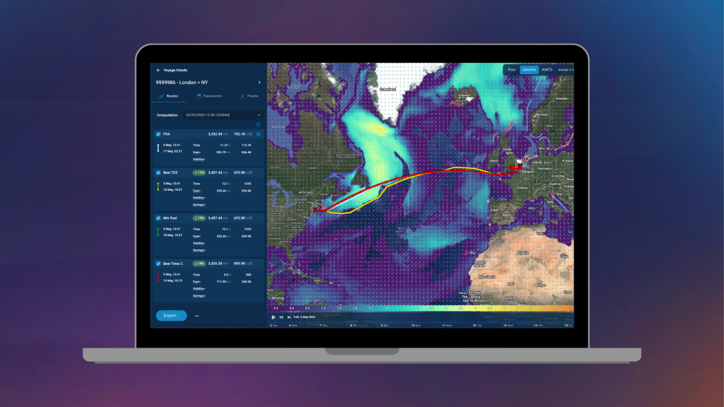
The result is not one isolated route recommendation. It is a set of optimised voyage scenarios that can be evaluated against the priorities that matter most to the operator. Depending on operational requirements, that may include minimum fuel consumption, fastest transit time, just-in-time arrival, strongest TCE outcome, charter party-aware routing or CII-aware routing.
That flexibility matters because operators are not all optimising for the same outcome. Chartering teams may prioritise margin and schedule reliability. Masters may prioritise vessel handling and safety. Fleet performance platforms may require multiple viable voyage options rather than a single prescribed route. Multi-objective optimisation reflects operational reality far more accurately than a one-dimensional routing output.
According to Theyr’s public product information, T.VOS evaluates more than 300,000 voyage estimations per computation, processes around 40 million waypoints, can return up to 100 optimal routes and refreshes dynamic routing up to four times per day. The platform is also API-delivered and system-agnostic, making it easier to integrate into existing maritime workflows and digital platforms.
That architecture is particularly valuable for maritime technology providers because it keeps commercial logic close to the environmental and vessel-performance data layers rather than separating them into disconnected systems.
From weather exposure to commercial performance
The strongest case for voyage optimisation is not only technical. It is commercial. Poor weather decisions do not just create navigational challenges. They can become margin issues when excess fuel is burned to maintain speed. They can become claims issues when charter party performance falls short of expectations. They can become compliance issues when emissions performance deteriorates over the course of a voyage.
This is where the wider T.VOS ecosystem adds further operational value. The Dynamic Charter Party Module uses the same weather and ocean intelligence layer as the optimisation engine to assess how conditions affect speed, fuel consumption and charter party performance in real time. That gives operators visibility into developing issues while corrective action is still possible.
The same principle applies to environmental performance. As CII requirements and broader decarbonisation pressures continue to reshape shipping operations, routing decisions can no longer be separated from emissions performance. A better route is not simply safer or faster; it may also protect the vessel’s commercial and regulatory position.
In the right optimisation framework, metocean data stops being a background feed and becomes a live operational decision input with direct influence on fuel consumption, routing, speed, compliance and profitability.
The real value of metocean data
Metocean data only becomes commercially valuable when it changes operational decisions.
A dashboard filled with wind, wave and current layers may look sophisticated, but visualisation alone does not improve voyage performance. The value appears when a platform can connect changing environmental conditions to vessel behaviour, vessel behaviour to fuel and schedule performance, and those outcomes to the commercial realities of the voyage.
That is the real shift from traditional weather routing to real-time voyage optimisation.
For operators, owners and maritime technology providers, the question is no longer whether weather matters. The question is whether the technology can convert changing weather and ocean conditions into better operational decisions quickly enough to produce measurable commercial impact.
That is where T.VOS is designed to operate. It is not simply another weather routing layer. It is a multi-objective optimisation engine built to turn real-time metocean data into practical voyage decisions that improve safety, efficiency and commercial performance simultaneously
Frequently Asked Questions (FAQs)
What is weather routing in shipping?
Weather routing is the process of using forecast and observed marine conditions to recommend the most suitable route for a vessel. In modern shipping, it increasingly includes route, speed and fuel decisions rather than route choice alone.
What is metocean data?
Metocean data combines meteorological and oceanographic information such as wind, waves, swell, currents, pressure and temperature. In voyage optimisation, it forms the environmental input layer used to predict vessel performance along a route.
How often should a voyage plan be updated?
There is no universal rule, but voyage plans should be reviewed whenever forecast conditions change materially or vessel performance diverges from original assumptions. On long ocean passages, regular in-transit updates are essential to maintain commercially efficient routing and speed decisions.